
DESTRUCTION BY PHOSPHATE MINING


The destruction on the edge of Te Aka sacred village site on Banaba 1960s
For commercial purposes or publication, we ask that copyright approval and acknowledgment
of Author's and source can be quickly obtained through Emailing our Office with your request.
If approval is not sought we will view the matter as an infringement against 'copyright'.
News clippings remain the copyright of the individual Newspapers concerned -
All material in this Web Site is Copyright © K. Sigrah & S. M. King 2001 All Rights Reserved.
Google satellite view of devastated Banaba today
Buakonikai Village
The Banaban village of Buakonikai was situated on the lush central plateau and supplied the Banabans with an abundance of food trees.
This photograph was taken of the village in 1932 before mining began.

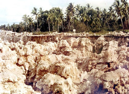
Mining 'topside' Buakonikai Village, Banaba 1968
This is the devastation left by Phosphate mining on Banaba, and shows the stark pinnacles left after mining is finished. At Buakonikai the depth of mining went down to 80 feet. Today from an original island consisting of 1,500 acres, only 150 acres around the shoreline remains unmined. The rest of the island, as seen in this photo is left barren and uninhabitable.

Mining early 1920s

Mining 1910s

Mining 1970s while the UK Court Case was underway surrounding sacred 'Te Aka' village site